Richards Mountains to the Sea - April 2012
Richard’s Mountains to Sea Trek April 19th – April 26th
2012
New Zealand South Island – Mt Cook to the Pacific Ocean

Day 1 - 7km
1pm Ice melt at the Hooker Glacier lake beneath Mount Cook to
village
 My Father joined me to trek up to the Hooker
Glacier terminal moraine and iceberg lake, a distance of 4.6km to the starting
point for my journey. Clear views of
Mount Cook and all surrounding mountains on a hot then cool afternoon as the sun
dropped beyond the Southern Alps. Face
refreshed with a wash in a running brook as we wander along well marked DOC trail
and over swing bridges. Wrapped up with warm layers of Kathmandu fleece and
Macpac Event jacket, beanie and gloves. Energized by the oxygenated air, moving
with the flow of the Hooker river on this short section of the trek to the Mt
Cook village arriving at 5.50pm, to night over at the YHA.
My Father joined me to trek up to the Hooker
Glacier terminal moraine and iceberg lake, a distance of 4.6km to the starting
point for my journey. Clear views of
Mount Cook and all surrounding mountains on a hot then cool afternoon as the sun
dropped beyond the Southern Alps. Face
refreshed with a wash in a running brook as we wander along well marked DOC trail
and over swing bridges. Wrapped up with warm layers of Kathmandu fleece and
Macpac Event jacket, beanie and gloves. Energized by the oxygenated air, moving
with the flow of the Hooker river on this short section of the trek to the Mt
Cook village arriving at 5.50pm, to night over at the YHA.
Day 2 36km
6.53am YHA Mt Cook National Park to Big Rock Steam
 Predawn start, minus 2
degrees in a frosty landscape as I head towards Lake Pukaki in the still air of
a another classic autumn day. Not a cloud in the sky, not a soul in sight for
the first few hours in the presence of towering peaks of snow and ice. Set a steady pace stopping every two hours to
refuel with trail mix while mindful to keep the water/juice levels up as the
temperature increase to 18-20 degrees Celsius.
Predawn start, minus 2
degrees in a frosty landscape as I head towards Lake Pukaki in the still air of
a another classic autumn day. Not a cloud in the sky, not a soul in sight for
the first few hours in the presence of towering peaks of snow and ice. Set a steady pace stopping every two hours to
refuel with trail mix while mindful to keep the water/juice levels up as the
temperature increase to 18-20 degrees Celsius.
My constant companions were
paradise ducks, hawks, rabbits and merino sheep and ice feed streams that sang
their song as they flowed at their own pace towards the Tasman river and Lake
Pukaki. Lunch break at Glen Tanner then in good spirits onward past Dead horse
creek, Roys creek to bath in the freezing stream, past Petes Lookout to pick up
point at 4.15pm. Exceeding expectations for the distance traveled and exhilarated
by my travel through sub-alpine terrain. Twizel house to
overnight.
Day 3 33km
6.59am Big Rock Stream to Haldon Boat Harbour
 My support crew,
Dad, dropped me back on the road, another freezing, calm and clear to the
horizon. Used the head light to warn on coming traffic of my presence, quickly
getting to a steady walking pace, following the white line on the edge of the
road. The stillness of nature early morning was astonishing, not a sound except
for the flow of water.Through the wildling pine forest for 10kms, past a
lavender trial north of the organic Pukaki Downs station, walking the straight
roads to Pukaki Dam and lookout. Numerous bus loads and camper van traffic
stopping to bask in the magnificent vista of blue sky and lake (very low water level),
white ice peaks, grey and brown mountain slopes, golden tussock and willows and
green patches of forest and irrigated pasture. Reflected on my work at this dam
site 37 years ago for the Ministry of Works, soil laboratory. Moved off down
the northern side of the Pukaki River bed, following a boulder laden 4x4 track
past the chimney remains of a stagecoach hotel , an arid landscape of Matagouri
and rosehip vegetation, noting the spent gun shop cartridges and rabbit
population .
My support crew,
Dad, dropped me back on the road, another freezing, calm and clear to the
horizon. Used the head light to warn on coming traffic of my presence, quickly
getting to a steady walking pace, following the white line on the edge of the
road. The stillness of nature early morning was astonishing, not a sound except
for the flow of water.Through the wildling pine forest for 10kms, past a
lavender trial north of the organic Pukaki Downs station, walking the straight
roads to Pukaki Dam and lookout. Numerous bus loads and camper van traffic
stopping to bask in the magnificent vista of blue sky and lake (very low water level),
white ice peaks, grey and brown mountain slopes, golden tussock and willows and
green patches of forest and irrigated pasture. Reflected on my work at this dam
site 37 years ago for the Ministry of Works, soil laboratory. Moved off down
the northern side of the Pukaki River bed, following a boulder laden 4x4 track
past the chimney remains of a stagecoach hotel , an arid landscape of Matagouri
and rosehip vegetation, noting the spent gun shop cartridges and rabbit
population .
Increased the pace as
pre arranged to meet up with friends at boat harbour. The boulders and rocks
were smashing into my trail shoes, cutting toes. Perhaps I should have worn my
boots! Moving through dense planted golden willows past riverbeds of Californian
poppies, over the iron bridge and south to link with father and friend at the
jetty for 5 minute boat trip across to Ohau C boat ramp and return to rest up
at Twizel base.
Day 4 - 17km
9am Tekapo River Bed, near Haldon Camping ground to Black Forest
Station homestead
4X4 drive through three
rivers to starting point then walked up to my knees in swift flowing water, along
the northeastern shore of Lake Benmore, through dense willow and wetlands, over
and around fences and gates. Topo maps proved to be critical to navigating the
terrain. Jumped over an electric fence and landed on the edge of my right
heel…. bruised and strained. Limped on placing weight on front of foot arriving
at the Black Forest Station homestead to request anti –flamm for sore foot.
Stayed the night in lodging
at the high country station with a stunning view north to Mt Cook in an idealic
part of the high country I had not visited before. Prepared food for a hearty
meal, gazing out at the stream and chestnut trees beyond the front deck.
Day 5 38 km
6.45am Black Forest
Station to Otematata township
Another sub zero morning
with tussock rigid with frost and an aching foot that improved with movement.
Off up the Black Forest river unsure of if foot would allow me to continue.
Decided to give one hour then check…. Okay when placing weight on front of
foot, but this produced blisters!
Following the mighty
power line that feed the North Island, the next 8 hours were the most
challenging up over three mountain passes with lots of will and endeavour.
Found stopping every hour during the after noon heat essential to replenish
fluids and to snack on organic chocolate with nuts and dried fruit. At best
this was my marathon with distant views to lake, deceptively close yet along
way off. A trusty stick supported the right leg, with lots of huff and puff
over Montys and Sugar Loaf passes. This was a real test of my Auckland pre-trek
preparation, of endurance and fitness. The sole person I saw this day was a
trapper on a farm bike. My companions were rabbits and a pair of paradise ducks
that circled me time and again.
Appreciated the breeze
to cool down and the small streams to wash in but not drink the potentially
contaminated water. Stunning gold poplars and willow trees were at there best
along the edges of the clear calm waters of Lake Benmore. At the dam lookout
rested up for the final leg across the dam and down to the lodge stop and a
long well earned shower. 9 hours 30 minutes walk time.
Day 6 28km
Otematata to Kurow
 7am start along the
south side of highway 83 on a warmer morning ,northwest breeze at my back with
the Lakes Aviemore and Waitaki visible to the north. The best Autumn on record helped
to ripen the wild apples, deposited out of cars during the 1950-1960s along the
roadside … surprising good eating. Tossed the cores back into the grass for
future apply trees.
7am start along the
south side of highway 83 on a warmer morning ,northwest breeze at my back with
the Lakes Aviemore and Waitaki visible to the north. The best Autumn on record helped
to ripen the wild apples, deposited out of cars during the 1950-1960s along the
roadside … surprising good eating. Tossed the cores back into the grass for
future apply trees.
Wild apricots, hawthorn
berry, pear trees also found along this section of road. The landscape is in a
dry zone with few streams and flora notably around the margins of the lakes.
Traffic was a hazard today with the need to get right of the road into the
ditch to avoid impact with big trucks and tourist buses. Bumble bees seem to
take a liking to my citrine coloured Macpac Event Jacket seeking to pollinate
me!
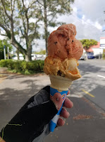
Booked into Kurow
Camping Ground cabin, resting up foot and headed for the towns shops to eat the
biggest ice creams you get anywhere, chat with locals and scan the famous
second hand collectors store where the operator would rather shoppers not buy
his stock…. just browse. Each evening involved a planning and mapping session,
packing gear and an early night for the next days trek.
Day 7 - 33km
6-58am ANZAC day…. Kurow
to 500 metres west of Georgetown
Along the highway oat
trees were planted every mile to remember the local soldiers who fought in the
First World War, many were brothers. The long straight roads
were a challenge in terms of seeing how far the road stretched into the
distance. The best strategy was to aim for a line of trees, a building or ridge
to reach, then reset goal for the next feature to focus the mind and body.
Down into the low land
Waitaki river valley past Maori rock drawings, vineyards and into intensive
dairy land. Drank 30litres of water and juice on another hot day stopping at
Duntroon’s Faulty Towers for a vegetarian lunch and phoned the Oamaru Wednesday
Walker group to arrange a roadside pickup near Georgetown at 3.45pm. Rest up in
Oamaru, with blistered and aching feet but otherwise eager to get back for the
final day to the Pacific ocean.
Day 8 - 25km
8am West of Georgetown
to Waitaki river mouth and Pacific Ocean
Moved off highway 83 to
Atkinson and Macpherson gravel roads. Weather
remained fine with increasing cloud as the golden spell of weather comes to an
end. Notable observations were magpies in full song, dairy machinery on the
move feeding out silage to cows, herds of cows crossing the road…yes they will
stop and give way to humans.
 Over the railway line
the last 5 km seemed to take an age with the last section sliding over foreshore
shingle bar to the outflow of the Waitaki river into the Pacific ocean at
2.15pm
Over the railway line
the last 5 km seemed to take an age with the last section sliding over foreshore
shingle bar to the outflow of the Waitaki river into the Pacific ocean at
2.15pm
Washed hands and face in
the river mouth, gazing at the torrent of water surging out into the calm sea, looking
back over the past eight days by turning to the west in the direction of where
I had come from…..and turning back to the river and sea.
A phone call to my
brother to collect and return to Oamaru. Distance 217km recorded on Kathmandu padometer
Reflections
˜
Being adventure smart and safe in the outdoors
˜
Avoid electric fences!
˜
Feeding off natures energy helped me endure the tough days
˜
Mt Cook commanded the landscape
˜
Oasis of tranquility at Black Forest Station
˜
Taking the high road over the mountain ranges
˜
Weather perfect every day
˜ Travelling
down from the mountains as early Maori did with food and Paunamu
˜ Water tells a
story in its journey to the sea
˜ Reconnecting
with the land once travelled
˜ Next
challenge-Alps to Sea by Mountain bike 2013
Richard Main - May 2012